Technical Information
Survey
Several different types of survey will be undertaken at many different site-types as part of the Bennachie Landscapes Project.
Sketch Plans
Usually in advance of more detailed survey, such as plane table survey, sketch plans are produced. Sketch surveys are unmeasured, or roughly measured with paces, and focus on details such as the location of doors and windows, as well as other interesting architectural features, such as hearths and whether walls join or abut. This allows the surveyors to have an idea of the size of the site, roughly what it should look like, and also allows for any additional discussion and investigation at different points of interest. For instance, the presence of phasing can often be seen in certain structural details. If a site is examined in detail using a sketch survey, the full detailed survey, which comes later, can be planned and undertaken much more efficiently and effectively.
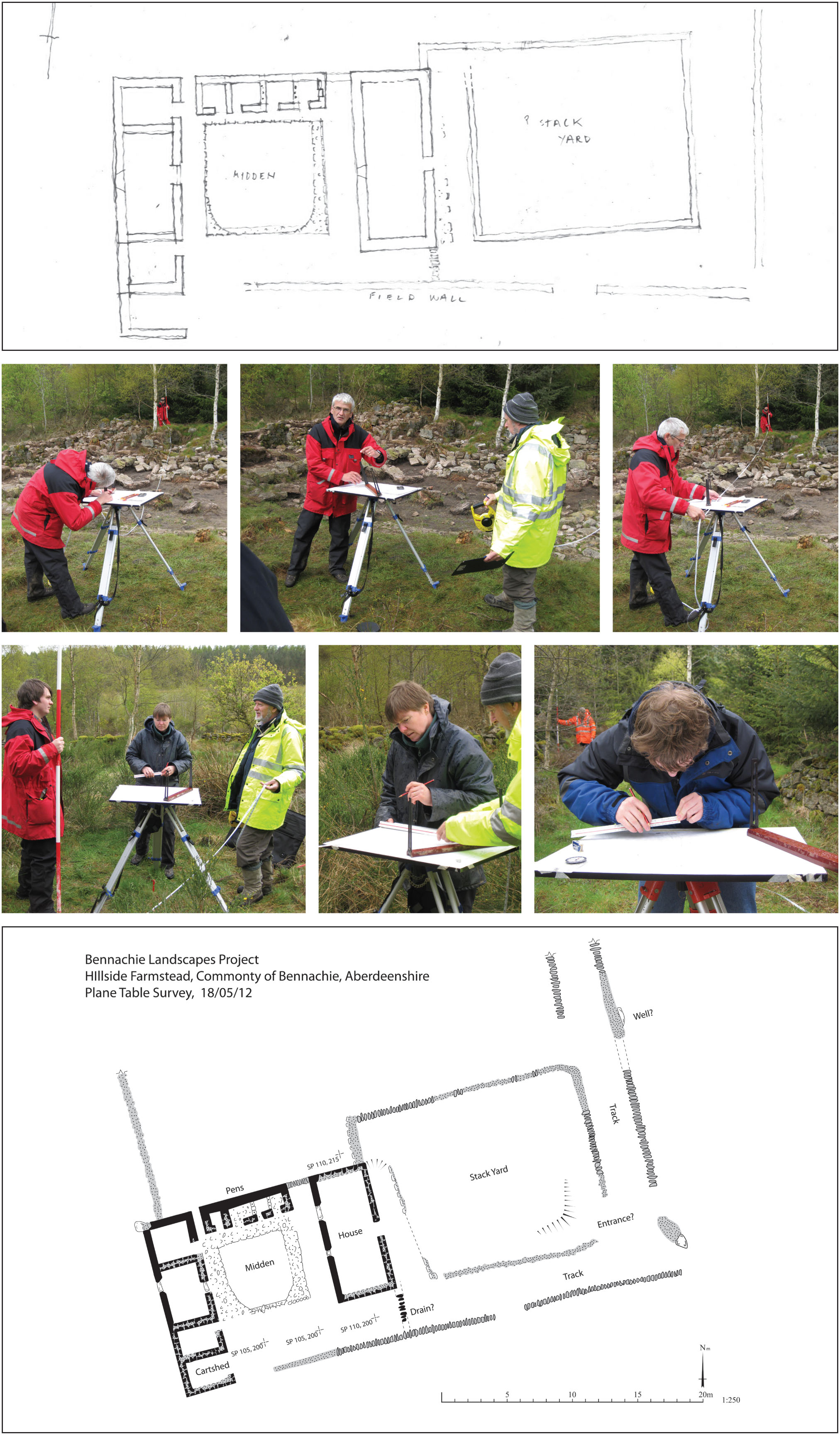
Plane Table Survey
This type of survey allows the accurate recording of buildings and other architectural features, such as field boundary walls, with little specialist equipment, and minimal training. The surveys produce scaled drawings that illustrate the size of features, their spatial relationships to other objects, and record the building materials used in construction. The chronological order in which buildings were constructed or altered can also sometimes be shown, allowing for on-the-ground analysis and interpretation by volunteers.
In a relatively short amount of time, useful and accurate records of the structural remains of sites can be recorded. Once surveys of all structures in the Colony have been undertaken, they will be compared and contrasted with the aim of answering some of the research questions relating to the ‘micro-history’ of the Colony in mind. They will also be used to compare the Colony to nearby contemporary settlements to identify any similarities and differences between them.
The Royal Commission on the Ancient and Historical Monuments of Scotland has produced A Practical Guide to Recording Archaeological Sites
GPS Survey
For larger scale architectural and landscape features, GPS (Global Positioning System) survey can be the best method to use. When using a differential GPS system, an accuracy of as little as a few centimetres can be achieved. Rather than undertaking a plane table survey over large areas like enclosed fields, which would involve joining together many individual plans, GPS is used for mapping. This technique is particularly useful for long, linear features such as field boundary walls and pathways. Several points are recorded along the length of the feature, and this information is then plotted onto maps, allowing the rapid charting of the built landscape.
Excavation
Though by no means the only activity undertaken by archaeologists, excavation is by far the best known, and certainly is very important. During the Bennachie Landscapes Project, both full-scale excavation of entire structures and small-scale test pitting will be undertaken in order to recover as much information about the lives of those living in the Colony as possible.
Shovel test pitting
This type of excavation involves setting up a grid over a large area, and digging small holes in order to locate artefacts. At each intersection on the grid, a 20l sample of soil is excavated and sieved, with all artefacts recovered. As the test pits that the artefacts are removed from are plotted, we can map how far the influence of the colonists spread over the hill. As manuring practices at the time often involved the spreading of rubbish middens over the fields, we can trace this activity through the presence of broken pottery, glass and other items that would have been discarded in the midden.
Over the course of 2011 and 2012, test pitting was undertaken at the Colony crofts of Shepherd’s Lodge, Hillside, Gouk Stone and A-Frame. We were very fortunate to have so many enthusiastic volunteers, without whom none of the artefacts would have been recovered. From this work we have discovered several hundred ceramic, glass and metal artefacts. Preliminary results indicate widely differing agricultural strategies across the Colony, perhaps one of the first indications of how life on the hill varied between different households. A selection of the artefacts recovered can be seen here.
Full Scale Excavation
Over the first two weeks of July 2013, the team from the Bennachie Landscapes Project, along with community volunteers and a number of University of Aberdeen students, will undertake full-scale excavation at two (possibly three) of the dwellings in the Colony with several questions in mind.
- How were the buildings constructed?
- Do the buildings conform narrowly to ‘Improvement ideals’; are there other kinds of influences being expressed?
- How were the buildings used?
- Did this use change over the life of the Colony?
- Can we identify similarities and differences between each farmstead within the Colony?
- What do the artefacts we uncover tell us about daily life for those living on the Colony?
As our survey and test-pitting work builds towards the full excavation, we will be adding to, and refining this list of questions as we find out more about how the colonists lived and worked on this land.