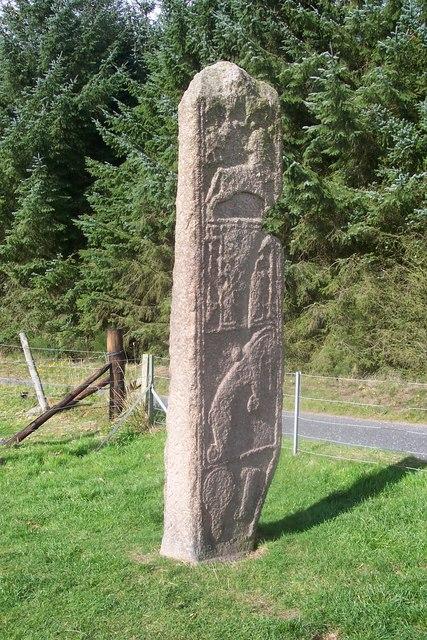
Accessibility

Scheduled Monument

Learn more about scheduled monuments on and around Bennachie which are nationally important archaeological sites or historic buildings.

Further Information

Sam1 Afforsk Stone

Afforsk Cross Stone

Afforsk Cross Stone. Large Stone with Pictish Cross and Ogham Symbols.

About 40 metres into the forest from the most northerly field of Mains of Afforsk there is an eminence topped with a Bronze Age cairn. At the edge of the cairn there is a stone which attracted the attention of Mike Davidson, a former Clerk to the Bailies of Bennachie. It was covered with moss which he removed and was astonished to find a Pictish incised cross. Archaeologists discovered on its edge a line of Ogham symbols, a primitive form of writing.

For more information see https://canmore.org.uk/site/80727/mains-of-afforsk

Map Reference: NJ 695 208 Coordinates: (57.276814,-2.5074667)

Berry Hill

Berry Hill, Remains of a Prehistoric Enclosure.

One of a series of low hills around the foot of Bennachie, it lies on the north side of the hill rising up from the boggy ground bordering the Gadie Burn, air photographs showed there was a wall that enclosed the top of the hill and there was a stone hut circle on the western slope, at the base of the hill on the north side there are tumbled remains of a 19th century cottage.

For more information see https://ancientmonuments.uk/122251-berry-hillenclosure-600m-south-west-of-bogend-west-garioch-ward#.X6RVSOQTtaQ

Map Reference: NJ 668 252 Coordinates: (57.316147,-2.5528351)

Maiden Castle

Maiden Castle, Pictish Fort.

Close to the Rowan Tree Car Park, is a Pictish fort standing on a rocky outcrop surrounded by a ditch and a circle of mature trees. Excavations at the site have confirmed settlement in the area from 7,000BC up to mediaeval times. During excavations in 2009 a rare Iron Age cobbled road, a stone pendant, and a 1,000-year-old sparkling glass bead were discovered. It would have provided early inhabitants with a panoramic view of the Garioch, the neighbouring ancient hilltop forts on Mither Tap and Dunnydeer, and the Glens of Foudland, gateway to the Highlands. Maiden Castle was a very high-status residence, probably home to an ancient prince or king. There are only three or four sites like this in Aberdeenshire. The excavations have now been filled in to preserve the site

For more information see https://canmore.org.uk/site/18182/maiden-castle

Map Reference: NJ 694 244 Coordinates: (57.309144,-2.5095721)

Sm1 Maiden Stone

Maiden Stone

Maiden Stone, Stone with Pictish carvings.

Note this stone is covered in the winter to protect it from the weather.

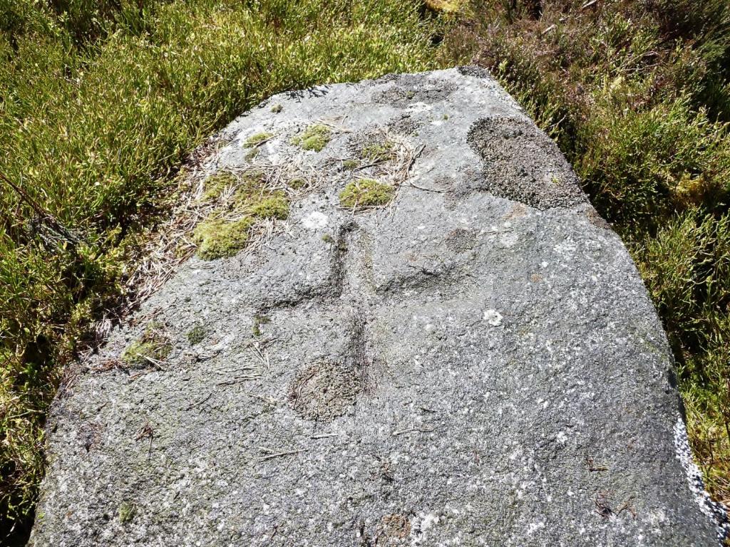
The Maiden Stone belongs to a slightly later period (around 700–800 AD) and has the symbols standing out in relief. It stands almost 3.5m (11 ft) high and has beautiful art work all over it. On the east side are four panels, the bottom having two figures, a mirror and a comb. The next panel has a representation of an “elephant”; above that a two legged rectangle and Z rod, and at the top four- legged beasts too faint to identify – some think the lower one is a centaur. The west side of the stone has sadly become very difficult to decipher due to the impact of weathering. The lower figure is a pattern of circles and Celtic knot work which is continued in what must have been a fantastically beautiful wicker –work pattern on the sides, this pattern probably being based on the extensive use of willow by early inhabitants in the construction of houses, boats, shields, baskets and so on. Above the circles stands a Celtic cross over 5 ft high, but the detail of the figures above the cross has disappeared.

See also: https://canmore.org.uk/site/18978/chapel-of-garioch-the-maiden-stone

A famous legend probably gave the stone its name. The legend of the lovely Maiden of Drumdurno, tells of a rejected suitor who met the Devil in Pittodrie Woods and in exchange for his soul bought his revenge. It was the eve of her wedding when the maiden was baking oatcakes, singing at her work, when she looked up and there was a handsome stranger who wagered her that he would build a causeway right up to Mither Tap before she had finished baking her firlot of meal. “It sets ye weel to bake lass, gin ye had ony mair speed at it”. Thinking this but idle banter, she lightly promised her hand and heart would be his reward if he won. At twilight, her firlot was nearly all baked, she looked up and saw a causeway finished right up to the hill top and the handsome stranger whom she now recognised as Satan himself, coming to claim his reward. Terror-struck she ran to Pittodrie Woods, but the Devil caught her and as she cried for help, she was turned to a pillar of stone, known to this day as the Maiden Stone. The Mirror and Comb carved on this Pictish sculptured stone were pointed out by the superstitious as the maidens girdle and baking board, and the crack near the top as the mark of Satan’s hand.

Close to Maiden Stone is the Statue of Persephone carved in 1961 by Shaun Crampton.

Also see https://canmore.org.uk/site/274091/statue-of-persephone

Map Reference: NJ 705 246 Coordinates: (57.311013,-2.4913380)

Sam2 Hill Fort Mither Tap

Mither Tap Fort

Mither Tap Fort, 518 m, Iron Age Hill Fort.

Mither Tap (or Mother’s Breast) has cliffs of hard wearing granite or tors which mean that it is potentially very dangerous place so be careful especially in a strong wind.

Most people who climb the Tap will approach the final ascent through an entrance corridor in a massive but ruinous wall – the remains of an Iron Age Hill Fort (c. 500 BC-500AD ). There are at least two walls surrounding the summit plus various terraces with signs of dwellings. In 2019 on the west side of Mither tap a well was excavated but is now covered.

For more information see https://canmore.org.uk/site/85507/mither-tap-of-bennachie

Map Reference: NJ 682 224 Coordinates: (57.291097,-2.5292317)

Sam3 Tillymuick

Tillymuick

Tillymuick 254 m, Hill Fort.

This is a hill fort and is the largest enclosed site in North East Scotland. It is situated to the west of the Back O’ Bennachie Car Park. The low rounded summit is enveloped by a stone bank approximate 4m in width and 0.5 m in height. It is difficult to trace the entire circuit but a gap is apparent on the west side and may be the original entrance. Within this stone bank are 8 huts, each 7-8 m in diameter. It is now surrounded by forest and covered with Heather.

For more information see https://canmore.org.uk/site/18212/tillymuick

Map Reference: NJ 649 245 Height: 254 m Coordinates: (57.309717,-2.5842775)

Please see Bennapedia and Bennapedia Map sections.